

ALBANY & EASTERN NEW YORK GENEALOGY
Cliff Lamere Albany, NY
Maps & Gazetteers
Last updated Sep 2006
GAZETTEERS
NY - Present-Day Populated Places (Nancy Dixon) Source: NYS Department of Transportation.
NY - Cities, Towns and Villages (NY State Library) All hamlets are missing. Previous link is better.
NY - Towns, Villages, etc. that changed their names (NYGenWeb)
NY - County Highways (N. W. Perry)
USGS Geographic Names Information System for US and Territories (USGS) You can search for the names
of cemeteries, churches, parks, airports, cities, counties, townships, lakes, rivers, mountains, or just about
any physical feature named on a USGS map.
Geographic Names Information System (Peabody Museum, Yale)
Index of NY Cities, Villages, Towns in 1890 (NYGenWeb)
Index of NY Town(ship)s on USGS Topographical Maps (unh) 20th and late 19th centuries. The numbers
represent the number of different maps on which each Town appears.
US Gazetteer (US Census Bureau)
Getty Thesaurus of Geographic Names (Worldwide) (getty)
![]()
MAPS
INTERNATIONAL
The Netherlands (LDS)
The Netherlands (Willem Rabbelier) Nine historical maps at the bottom of the page.
Maps of Ireland (Thomas J. Archdeacon)
UNITED STATES
*** US Map Showing Distribution of 50,000 Surnames in 1850, 1880, 1920 and 1990 (Ed Hamrick)
Select a year and type in a surname. A map will appear unless the spelling of the name was not part of
the top 50,000 names for that year. Censuses were used for the first three dates, phone books for 1990.
Below the map will be important information (first paragraph). Try the next year, and so on. Once you
see how it works, choose All Years. The maps will display one after the other so that you will be able to
get an impression of migration patterns, if any.
US Animated Map of the Changing Boundaries of the 48 Contiguous States (Ed Stephan)
US Animated Map of the Changing Boundaries of the 48 Contiguous States 1790-1920 (Northeast Genealogy)
US Animated Map Showing Formation of the Counties (Ed Stephan)
USGenWeb Map of US Showing All States and Their Two Letter Codes (USGenWeb) Click on the
state and go to that state's USGenWeb site.
United States - 1895 County Maps for Each State (CFC Productions) Images from an 1895 US Atlas.
Drawings of US Cities ("Panoramic Maps") for 1847-1929 (Library of Congress) Has a zoom feature and a
search engine.
Historical Maps of the United States (utexas)
US Historical City Maps (mostly early 1900s) (utexas) 146 maps from 1830 to 1952.
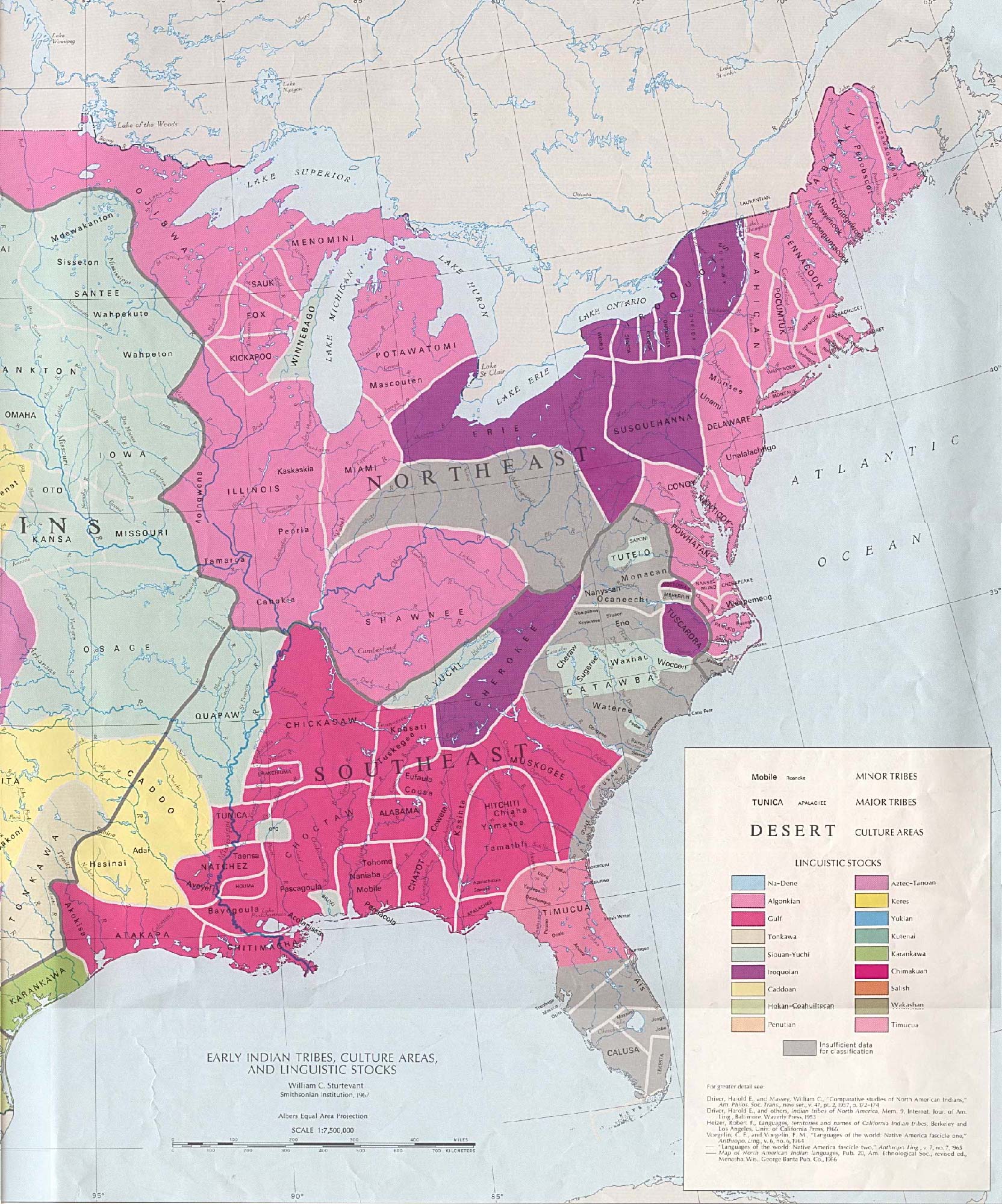
Early Indian Tribes, Culture Areas, and Linguistic Stocks - Eastern US (utexas)
Map of Original 13 Colonies and Land Held by England (1763-1775) (utexas) Some states had a different
shape in 1775. NY had only about 60% of its present land, but it included most of Vermont.
Maps - Regional, Street Maps, Areal Photos (Mapquest) Includes roadtrip planner.
BERKSHIRE CO., MA
Berkshire Co. (modern) (BerkshireWeb)
1876 County Atlas of Berkshire, MA by F. W. Beers (Laurel O'Donnell /USGenWeb) Has 42 maps.
NEW YORK STATE
New York State - Every County Named (NY GenWeb) Great map. The same page will allow you to link to
the NYGenWeb county sites.
New York State - county maps 1895 (CFC Productions) Taken from an 1895 US Atlas.
*** New York Animated Map 1683-1915 (Northeast Genealogy) Changing county boundaries shown.
New York Maps (74) Showing Changes in the Counties 1683-1915 (Northeast Genealogy)
New York State 20th Century Togographical Maps (US Geological Survey)
New York State Historical Topographical Maps (unh)
New York State Historical Maps 1556-1895 (SUNY at Stony Brook) 20 maps plus links to others.
New York State 1868. Map Showing Canals and Railroads (University of Rochester) The canals are shown
with solid, dark black lines. The railroads are shown with dashed lines.
New York Relief Map With County Boundaries Superimposed on it (Ray Sterner /Johns Hopkins U.) This
map will give you an idea of the physical features in the area where your ancestors lived. To see the
same map without the county lines, click HERE.
Maps of New York, New Jersey and Pennsylvania (djweaver) Many historical maps.
Hudson Valley Interactive Map (HV/Net) When the small map on the right appears, click anywhere on it
and a map of just that section will appear. Or, you can select from the drop-down list at the bottom of the
screen. Tourist attractions are included.
Map of the Present Counties of Albany, Rensselaer, Schenectady, and Saratoga (Capital District Regional
Planning Commission) Shows Cities, Towns and Villages. 'Central City' represents county seat.
Yahoo! Maps of NY Communities (Yahoo!) Type the name of the community and NY .
Major Palatine Settlements in NY, NJ and PA (Kathryn Parker)
ALBANY CO.
Counties Formed From Albany Co. (NYGenWeb) Has a colored map of New York State counties. Also
has a table showing the year each county was formed, each county seat, and gives the name of the
person who manages the county website (not entirely accurate). From here you can link to any NY
GenWeb county site in the state.
Albany (city) 1676 (NYS Museum) Earliest known drawing.
Albany Co. (ancient) 1755 - by Thomas Kitchen (NYS Museum)
Albany (city) 1770 - by Robert Yates (NYS Museum) Click on map for more text, and to enlarge it.
Albany Co. (ancient) 1771 - by Guy Johnson (NYS Museum)
Albany Co. (modern) (Poughkeepsie Journal)
Albany - Some Changes in Street Names and a List of Annexations 1815-1967 (Albany Co.)
![]() Bethlehem
(Town of) - modern (Tom Martin)
Bethlehem
(Town of) - modern (Tom Martin)
Bethlehem (Town of) - 1854 Gould map (Patricia Van Wagenen Harrison) Gives names of property owners,
but difficult to read some names. Adams Ville = Delmar.
Bethlehem (Town of) - 1866 Beers map (Patricia Van Wagenen Harrison) Gives names of property owners,
but difficult to read some names. Adamsville = Delmar.
![]() Berne
(Town of) 1866 - List of Property Owners only
(Barbara Bolster-Barrett / Darin Flansburg) A
list
Berne
(Town of) 1866 - List of Property Owners only
(Barbara Bolster-Barrett / Darin Flansburg) A
list
of the 454 properties on the two maps that make up the complete Town.
![]() Berne
(Town of) 1866 - Map 1 (Darin Flansburg / Barbara
Bolster-Barrett) Eastern 90% of the
Town.
Berne
(Town of) 1866 - Map 1 (Darin Flansburg / Barbara
Bolster-Barrett) Eastern 90% of the
Town.
Includes a List of Property Owners.
![]() Berne
(Town of) 1866 - Map 2 (Darin Flansburg / Cliff
Lamere) Western 10% of the Town.
Does not include
Berne
(Town of) 1866 - Map 2 (Darin Flansburg / Cliff
Lamere) Western 10% of the Town.
Does not include
the List of Property Owners.
![]() New
Scotland (Town of) 1866 (Darin Flansburg) Includes
insets of Clarksville and New Salem. Large file.
New
Scotland (Town of) 1866 (Darin Flansburg) Includes
insets of Clarksville and New Salem. Large file.
![]() New
Scotland (Town of) 1866 - List of Property Owners only (Barbara Bolster-Barrett / Darin Flansburg)
New
Scotland (Town of) 1866 - List of Property Owners only (Barbara Bolster-Barrett / Darin Flansburg)
A list of the 577 properties on the map.
![]() Rensselaerville
(Town of) 1866 (Barbara Bolster-Barrett / Janet Haseley /
Cliff Lamere) Includes five
Rensselaerville
(Town of) 1866 (Barbara Bolster-Barrett / Janet Haseley /
Cliff Lamere) Includes five
maps (Town and four hamlets) and a list of c. 660 property owners and businesses shown on the maps.
![]() Rensselaerville
(Town of) 1866 - List of Property Owners only (Barbara
Bolster-Barrett / Janet Haseley / Cliff
Rensselaerville
(Town of) 1866 - List of Property Owners only (Barbara
Bolster-Barrett / Janet Haseley / Cliff
Lamere) A list of c. 660 property owners and businesses shown on five maps.
COLUMBIA CO.
Columbia Co. (modern) (Poughkeepsie Journal) Shows the town(ship)s and is in color.
Columbia Co. (modern) (unknown) Can be enlarged.
Town of Ghent (1860s?) (Beers? / Jim Groat) Shows houses, and names the land owners.
GREENE CO.
Greene Co. (Poughkeepsie Journal)
Greene Co. (Hope Farm Press)
Greene Co. locations 1867 (about 25 maps) (nygreen2)
Greene Co. - Towns of Athens and Coxsackie 1884 (nygreen2) Shows patents.
MONTGOMERY CO.
The Stone Arabia Patent 1723 or 1823 (djweaver) 1723 on map, 1823 flashing in title.
Residents of the Mohawk & Schoharie River Junction in New York (1757) (djweaver)
Montgomery Co. 1829 (David H. Burr)
Montgomery Co. 1895 (djweaver)
Montgomery Co. Families Raided by Sir John Johnson in October 1780 - Map 1 (NYGenWeb) Mostly
Schoharie Creek drainage area.
Montgomery Co. Families Raided by Sir John Johnson in October 1780 - Map 2 (NYGenWeb) Mostly
Mohawk River Valley.
RENSSELAER CO.
Rensselaer Co. (Poughkeepsie Journal)
Troy Maps (10) plus one Surrounding Map (Uncle Sam)
SARATOGA CO.
Saratoga Co. 2000 (Capital District Regional Planning Commission)
1866 Maps & Transcribed Names of Property Owners. (David Pane-Joyce) 16 Village, 4 Town(ship) Maps.
Clifton Park (Canastagione) 1866 (David Payne-Joyce)
SCHOHARIE CO.
Schoharie Co. 1866 (Joyce Riedinger) Includes maps of Towns and Villages.
Schoharie Co. 1895 (CFC Productions) Includes surrounding counties.
SCHENECTADY CO.
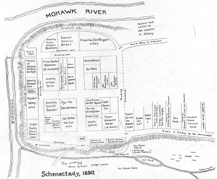
City of Schenectady, - Map of Stockade Section Showing Who Owned Various Pieces of Land (1690)
(Channon M. Moon) Shows names of some men killed in Indian Massacre. Names of captured or killed.
Schenectady Co. (1866 Beers Atlas) (Schenectady Co. Public Library ) Maps of Schenectady Co., Town of
Princetown and villages of Duanesburg, Bramans Corners, and Mariaville.
Schenectady Co. (c. 1750) (Schenectady Co. Public Library)
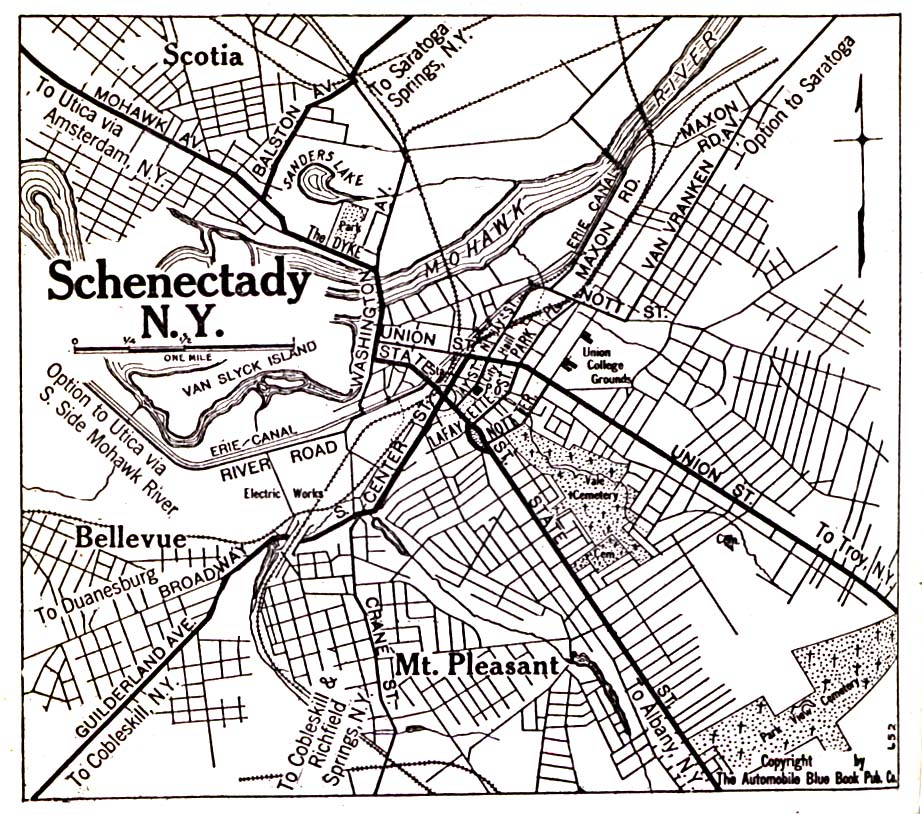
Schenectady (city) (1920) (utexas)
![]()
Albany & Eastern New York Genealogy (HOME)
Visitors since
![]()
![]()
![]() [storage]
[storage]