 [1]
[1]
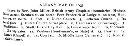
Fort Albany & Fort Frederick at Albany, NY
by Cliff Lamere Oct-Nov 2008
[1]
TABLE OF CONTENTS
A Short Early History of Albany
Forts in Albany, NY
Fort Nassau - Description
Fort Orange - Description
Fort Albany II (1676-1712c) - wood
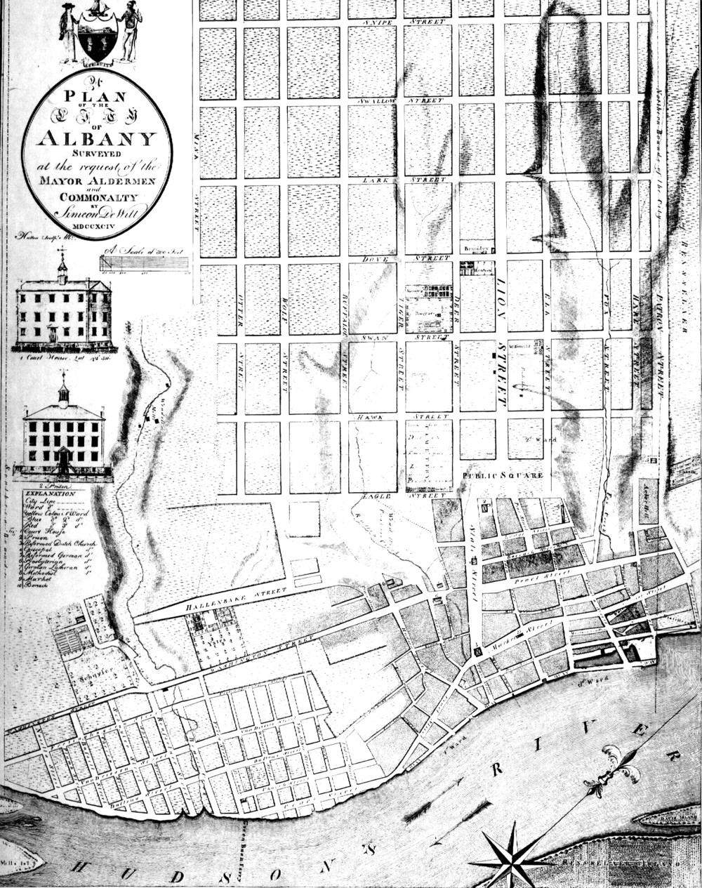
Albany in 1676 - French Map
The Plan of Fort Albany II in 1695
"The Fort of Albany" in 1695
Artist's Drawing of Fort Albany II
Dimensions of Fort Albany II
Fort Albany II on a 1695 Map of Albany
Fort Albany II on a 1698 Map of Albany
Fort Albany III ( 1702-1738) - stone
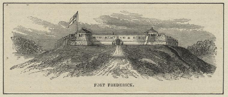
Fort Frederick (1738-1786c)
Fort Frederick Receives its Name
Location of Fort Albany III / Fort Frederick
When was Fort Albany III Torn Down? Where was it Located?
Was Fort Frederick built on a Prominent Hill?
![]()
A Short Early History of Albany
In 1609, Henry Hudson sailed up the river which later bore his name. He was looking for a shortcut to the East Indies, but the Hudson River failed to be that route. He stayed in Albany only a short time, trading with the Indians before sailing along the New England coast in continuation of his quest. Failing to find what he sought, he returned to the Netherlands where he reported that a rich fur trade could be developed with the friendly natives in the Albany area.
The Dutch returned about 1614 or 1615 and built Fort Nassau, a trading post, on Castle Island at the mouth of the Normans Kill (a creek at the present southern border of Albany). The location was selected to make it easy to trade with the Indians, many of whom brought their furs to the fort by boat. High flood waters caused the fort to be moved off the island to a spot on the mainland nearby, but it flooded there as well. Fort Nassau was abandoned in 1618.
Fort Orange was built in 1624 about two miles to the north of Fort Nassau. It was built near the Hudson River on flat lowland which is the river's flood plain. The location was near the present intersection of Madison Ave. and Broadway. Like Fort Nassau, Fort Orange was also subjected to seasonal and periodic flooding. Due to a land ownership dispute, in 1652 a palisaded town called Beverwyck was begun about 3/8ths of a mile to the north of the fort.
New Netherland remained a Dutch colony until 1664 when the English took control of it without firing a shot. They named the colony New York and changed the Dutch name of Beverwyck to Albany. At the same time, they changed the name of Fort Orange to Fort Albany. In 1673, the Dutch regained control, and the name of Albany became Willemstad (Willemstadt); Fort Albany was renamed Fort Nassau. The colony was permanently lost to the English a year later in 1674 at which time the name of the village again became Albany, and the name of the fort reverted to Fort Albany.
Dutch settlers and descendants made up the majority of the people who lived in the Albany area, and the language spoken in most homes was Dutch. In fact, as late as 1800 business in Albany was still being conducted in Dutch.
![]()
Forts in Albany, NY
There were four forts built within the boundaries of modern Albany, NY, all having disappeared before 1800. Three of the forts were known as Fort Albany at one time or another. To avoid confusion, I have assigned them numbers I, II and III. Histories of Albany or New York State say surprisingly little about Fort Albany II and III even though they were in the middle of today's State St. for over a century combined. Some historians have erroneously called both of them Fort Frederick. That misnomer not only persists today, it is common in new publications which depend on past histories rather than original documents for their information. This webpage attempts to clear up the confusion.
The forts associated with Albany were as follows:
Fort Nassau (1614c-1618 at two locations)
Fort Oranje (built 1624, the name sounds like Fort Aurania (an English spelling); later called Fort Orange)2
Fort Oranje/Orange (renamed Fort Albany (I) in 1664 by the English)
Fort Albany I (renamed Fort Nassau September 1, 1673 by the Dutch)2a
Fort Nassau (renamed Fort Albany (I) in 1674 by the English)
Fort Albany I (abandoned 1676, some visible remains still existed in 1812)3a
Fort Albany II made of wood (built 1676, gone by about 1710-1714)
Fort Albany III made of stone (begun 1702; completed 1738 and renamed Fort Frederick that year)
Fort Frederick (1738-1785c)
Fort Nassau - Description
"Hendrick Christiaensen... constructed a trading house on "Castle Island," at the west side of the river, a little below the present city of Albany. This building, which was meant to combine the double purposes of a warehouse and a military defense for the resident Dutch traders, was thirty-six feet long, by twenty-six feet wide, inclosed by a stockade fifty-eight feet square, and the whole surrounded by a moat eighteen feet in width... The little post was immediately named "Fort Nassau." It was armed with two large guns, and eleven swivels or patereros, and garrisoned by ten or twelve men. "Hendrick Christiaensen first commanded here.""3b
It is reported in some books that the French built a fort about 1540 on Castle Island and that the Dutch built Fort Nassau on top of the remnants.1b There is no truth to this claim according to Paul Huey, noted Albany area archeologist.
Fort Orange - Description
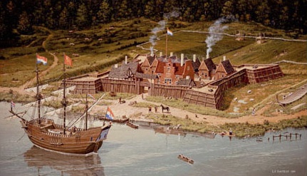
"The Dutch West India Company built Fort Orange (1624), on the west bank of the Hudson facing the ruins of Fort Nassau. Square Fort Orange was large, with palisaded walls each over five hundred feet in length, but it seldom housed as many as twenty-five traders and an equal number of the company's mercenary soldiers. Eight refugee families from the Spanish Netherlands were brought to provide labor and grow food for the fort, but they were relocated to Manhattan Island two years later for their own safety..."3c
"The location of the patroon's trading house, at the edge of
the moat around Fort Orange, may be proof of these good "Fort Orange,1635" by Leonard F. Tantillo
relations..."3d
Three Forts named Fort Albany
Fort Orange is mentioned in many reference books, including the circumstances under which it was renamed Fort Albany. For over a century two other forts were in the middle of the main street in Albany, yet very little is written about them in histories. They were also named Fort Albany, the second of those later being renamed Fort Frederick. Surprisingly few people have even heard about these two forts, and fewer still know that Fort Albany II (made of wood) was never called Fort Frederick, and Fort Albany III (made of stone) existed unfinished for 36 years before having its name changed to Fort Frederick.
Fort Albany I (Fort Orange) was a little south of the town of Albany and outside of its palisade. Fort Albany II and III were built inside the palisade surrounding early Albany.
Here are some quotes about each fort which do use its correct name.
Fort Albany I - 1670
"There, he continued in this function until 1670, when he was replaced by Captain Sylvester Salisbury, who was then commander of Fort Albany."3e
Fort Albany I - November 1674.
"Ensign Caesar Knapton is ordered to take Sergeant Thomas Sharpe and eighteen men with him to Fort Nassau (formerly Fort Orange and then Fort Albany) and formally receive its surrender."4
[The surrender resulted in the name becoming Fort Albany once again.] [The parenthetic statement was no doubt added by the later historian.]
Fort Albany I - October 1675
"Because of the terror created at Albany by King Philip's Indian raids, Governor Andros sends Capt. Anthony Brockholls and some recruits to strengthen the garrison of Fort Albany (formerly Fort Orange)."5
[The parenthetic statement was no doubt added by the later historian.]
pg 115
Fort Albany II - September 1688
"Gov. Andros... placing Capt. Jervis Baxter in command of Fort Albany."6
Which fort??????
Mr. Barclay had received a stipend of fifty pounds from the Propagation Society and an allowance as chaplain at Fort Albany.6a
Fort Albany III - 1706
"Request for a chaplain at Fort Albany, 1706."6b
![]()
Sources and additional quoted text are at the bottom of this webpage, but also on a separate webpage. It may easier to switch screens than move down and back up.
Footnotes: Sequential numbers are used to identify the footnotes. The numbers for images are in placed in square brackets [ ], and the numbers found in the text are superscripted. The footnotes may identify the source of the image or text, it may contain a link to the source, or it may contain additional comments.
omit? Click on a number in square brackets [ ] to read the source for a particular image or statement (on a separate page). Superscripted blue numbers refer to footnotes at the bottom of this webpage. Sometimes, these will be quotations from the source where I found the information; sometimes they will contain just a link to the source.
![]()
Fort Albany II (1676-1712c)
The Building of Fort Albany II
In 1676, just two years after regaining control of Albany, the English abandoned Fort Orange (then called Fort Albany) and built their own Fort Albany7 in Dutch-dominated Albany. They decided to build on higher ground than had been used by previous forts, partly to avoid the seasonal flooding still suffered by Fort Orange (Fort Albany I), and partly for its military advantage overlooking the Hudson River.8
Fort Albany II - March 1676
"Governor Andros returns to New York, leaving Seargeant Sharpe in command at Fort Albany (formerly Fort Orange, on the river shore), and the Governor orders a new fort, to be constructed at the head of Yonkers (State) street, overlooking the village of Albany and serving to protect it from roving tribes coming from the westward, each of the four bastions to hold six guns... the laborers commencing work upon the fort at once."9
If the new fort is called Fort Albany (II), what did they call the earlier Fort Albany? Fort Orange was a Dutch name to which the English objected just two years earlier, so they would not likely use that name. It may have been called Old Fort Albany, but perhaps just "the old fort."
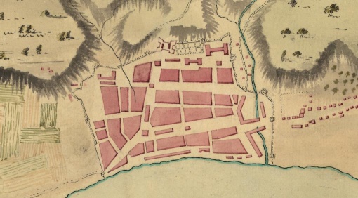
Beverwyck (early Albany) was begun in 1652. It was built partly on the narrow flood plain of the southward flowing Hudson River, but mainly it was built on the western slope of the river's fairly steep valley wall. The new fort was built about three-quarters of the way up the slope, on a street we now call State St. It was located downslope from today's State Capitol, but it overlooked all of Albany at that time.
Albany in 1676 - French Map
[top is West]
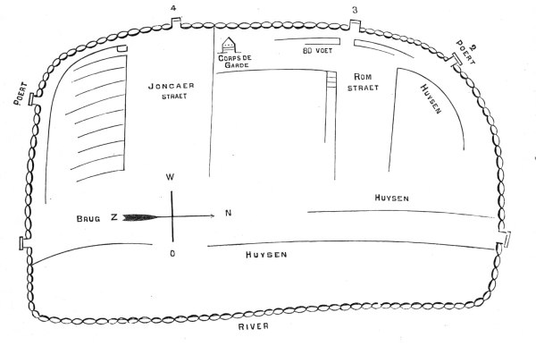
This is the earliest map of Albany that is still in existence. The only thing known about the map maker comes from a notation on the parchment manuscript which says, "French Map 1676."10 On it, Joncaer Straet was the Jonckheer Straat of the Dutch which later became simplified to Jonkers. Since Jonkers sounded like Yonkers in English, the name was later spelled Yonkers Street. Because of its width, at another time it was called Broad St. Its modern name is State Street.
Rom St. is today's Maiden Lane. Huysen means houses. Brug means a bridge (over the Rutten Kill). Poert means a gate. 80 voet means 80 feet, probably the width of the street at that point on the map.
Corps de Garde can be translated as "body of soldiers." A map from 1695 shows the street that it is on to be Pearl St. which led to one of the two north gates. "The guard-house occupied the old Elm tree corner on North Pearl street."11 Although it has been called a guardhouse, is it possible that the Corps de Garde was the new English fort (Fort Albany II)? If it was only a guardhouse, where was the fort on this map?
The 1695 map by Rev. John Miller (below) shows the fort at the top of State St. (which did not go to the top of the hillside at that time). The location of the Corps de Garde on this 1676 map is different from the actual known location of the fort, and it was not joined by the palisade on the north and south sides as was true of Fort Albany II. So, this cannot be the fort.
It is possible that this undated map was created a year or two earlier than 1676, thus explaining why the fort was missing. It is also possible that the map was made in 1676, but before the fort's construction had begun or had been finished.
Paul R. Huey calls the structure a blockhouse. "At the junction of State Street and North and South Pearl Streets was evidence of the colonial British blockhouse which had stood in the center of the street, and debris from the making of wampum from clam shells at this site suggests one way in which the idle soldiers there profibably passed their time."12 Wampum was called seawan at the time. Lacking any colonial currency, it substituted for money. It was expecially useful when trading with the Indians, but the colonists accepted it in trade for goods and services.
The Corps de Garde was some sort of military installation, probably small, and perhaps built not long after the English first gained control of the Dutch colony in 1664. Or, it could have been built even earlier than 1664 by the Dutch. As Beverwyck developed, it did not include Fort Orange which was a few modern blocks to the south of the town and outside of the palisade. Therefore, the Dutch may have felt the need of a group of defenders within Beverwyck's walls.
![]()
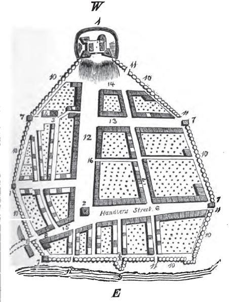
The 1695 Plan of Fort Albany II
The 1695 Plan of Fort Albany II - after drawing of Rev. John Miller, British chaplain13
South 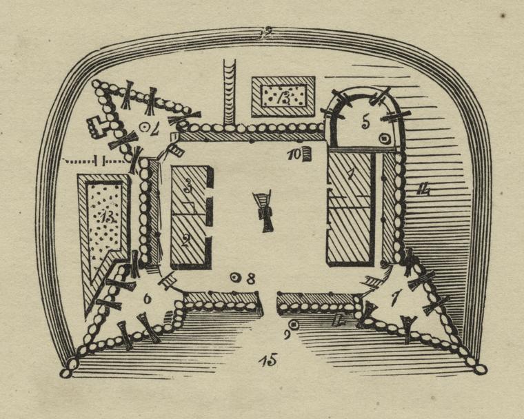 North
North
West is at the top. [14]
1. Governor of Albany's house 9. Sentry boxes
2. Officer's lodging 10. [a ladder? movable?]
3. Soldier's lodging 11. Sally port [left of 13, no number shown]
4. Flag-staff and mount 12. Ditch fortified with stakes
5. Magazine 13. Gardens
6. Dial mount 14. Stockade
7. Town mount 15. Fort gate
8. Well
The four corners of the fort consist of three bastions, numbered 4, 6, and 7 (the 4 looks like an upside-down 7), and 5 which is the rounded magazine where gun powder and guns would have been stored. The magazine has a different shape and it lacks the palisade wall which the rest of the fort has. The rounded magazine may have been made of stone to lessen the possibility of a fire and explosion that would surely have done great damage to the fort. 1 is the building below the magazine. The governor of the state of New York (not Albany) stayed there when visiting Albany. 20 cannons are shown, one of them being in the middle of the fort and aimed at the front gate.
This map is apparently a wood engraving of a drawing by Rev. John Miller. The engraver's name may be unknown. This image came from the digital collection of the New York Public Library. It had a title of Fort Frederick, but it clearly was not that stone structure. Fort Frederick was a different edifice and it was named for someone who was not born until after 1700.
The next map had a similar legend.
"The Fort of Albany" in 1695
This map, published in London in 1843, is another version of the previous 1695 map, but this one has a legend. The map shows an extra cannon at the lower left. The fort has been described as having 21 cannons, so this map may be more accurate. It was likely made for publication from the original map by Rev. John Miller.15
"The Fort of Albany" in 1695 by Rev. John Miller, British chaplain
South
 [16]
[16]
East
In these two 1695 plans of Fort Albany II, a rounded magazine is shown on the northwest corner of the fort. The later stone Fort Albany III (which became Fort Frederick) lacked that feature on diagrams of it. So, this is an easy way to tell the two forts apart on early maps.
Some Features of Fort Albany II
"On the West Angle [of the city] is the fort quadrangular strongly stockaded & ditched round having in it 21 pieces of Ordinance mounted."17
To slow down an attack, three sides of Fort Albany II were protected by a ditch fortified with stakes, a type of abatis. [Abatis: One of the oldest forms of defense for fortifications; the abatis is an arrangement of felled trees, with the branches facing outward from the defending position to impede the charging enemy. The tips of the branches were sharpened as spikes.] Local White Pine trees would have been very suitable for this purpose because, unlike deciduous trees, their branches come nearly perpendicularly from the trunk of the tree.
Although enclosed by the ditch, the fort was also protected by its own palisade wall. The logs are clearly represented in the two 1695 images above. Between the ditch and the fort, two gardens (13) are shown. To the left of the upper (west) garden was a sally port, a secret tunnel through which soldiers could make raids on the enemy.
The fourth (eastern) side of the fort apparently had a glacis for protection. [Glacis: A cleared bank sloping down from a castle's walls. It allows a clear line of fire in which attackers have nowhere to hide.] A cleared slope would agree with the many drawings and paintings of the later stone fort, so it seems likely that this wooden fort also had it.
The plan of the fort (above) has many lines of shading in the area of the front gate, which I believe represent the cleared slope. There was a similar shading on the north side of the fort between the palisade wall and the ditch. A slope apparently was also there. Notice that just outside the palisade on the south and west sides of the fort, but inside the ditch, there are gardens. If the north side had been suitable for gardening, one almost certainly would have been there as well.
Rather than constuct the fort on sloping land, I suspect that the English dug into the hillside to make a horizontal step on which to build Fort Albany II. If I am correct, the excavated dirt could have been put in front of the fort to form a slope even steeper than the natural grade of the land (for greater safety against invaders).
In 1689, Chevalier De Calliers, Governor of Montreal described Fort Albany II and Albany this way: "About as large as Montreal, surrounded by picquets, at one end of which is an earthen fort defended by palisades, and consisting of four small bastions. There is a garrison of 150 men, of three companies, in the Fort and some pieces of cannon. Said town of Orange (Albany) may contain about 150 houses and 300 inhabitants, majority of whom are Dutch, and some French refugees, with some English."18.Gerber3-79-also Annals
Artist's Drawing of Fort Albany II
The following is a small part of a larger drawing of the city of Albany done in 1985 by well-known, and highly respected, local historical artist Leonard Tantillo. Titled "Albany, N. Y., 1686," the drawing depicts Albany in the year that it received its municipal charter. The drawing was based on the 1695 map of Rev. John Miller and the 1698 map of John Wolfgang Roemer. Two pointed front bastions and the rounded northwest magazine can be seen. Close examination shows a slope between the north wall (on the right) and the ditch which goes around three sides of the fort.
 [20]
[20]
Dimensions of Fort Albany II
Edward Hyde (Viscount Cornbury) was colonial governor of New York 1701-1708. On September 24, 1702, Governor Cornbury wrote to the Lords of Trade describing the fort. "The fort is in a miserable condition. It is a stockaded fort about one hundred twenty feet long and seventy feet wide. The stockades are almost all rotten. There is but 23 guns in the fort, most of them unserviceable."1
The two plans of the fort above do not appear to have those proportions. Another plan of the fort, said to be by ROEMER???? contained a scale. If the scale and the plan of the fort were accurately drawn, the measurements of the fort were about as follows:
|
Without Bastions |
Including Bastions |
|||
| Front Wall | 142 feet | Front Wall | 172 feet | |
| Side Wall | 76 feet | Side Wall | 110 feet | |
Governor Cornbury may have been quoting approximate inside measurements along the ground. The inside wall was vertical. The walls measured about five feet in width at the top and about eight in width at the bottom, the interior of the wall being hollow.
Fort Albany II on a 1695 Map of Albany
The following Plan of Albany in 1695 was created by Rev. John Miller, British chaplain. There are several versions of the legend. Fort Albany II is usually listed as just "The Fort," but here the legend has an additional erroneous statement which calls it Fort Frederick.
The Stadt Huis (City Hall) is 8, next to the south gate on Handlers St. (originally Handlaar Straat, now called Broadway). Pearl St. and Handlers St. both led to north gates. The street that formed above (west of) Pearl was known as Barrack St. (later Chapel St.). The street later created a block above that was Lodge St. If the proportions are correct in this portion of the map, then the eastern edge of Fort Albany II was at about Lodge St.
"The fort designated on this map [by Miller] was known as Fort Albany, and was built after the surrender of the province to the English in 1664... Fort Orange, soon after the completion of the new fort, was abandoned, and the land around it divided up into gardens."Gerber3
Fort Albany II on a 1698 Map of Albany
This map, made in 1698 by John Wolfgang Roemer, shows the same location for this Fort Albany II as the previous map by John Miller.
1698 Map of Albany by John Wolfgang Roemer
South  [30]
[30]
East
In the lower left corner of the map is shown the four-bastioned Fort Orange, well outside the palisade surrounding Albany.
DONE TO HERE NOV 24
![]()
The stone Fort Albany III was uphill from the wooden Fort Albany II. "While in Albany, Cornbury undertook to replace the stockaded fort with a new one of stone. Plans were set in motion to have the fort redesigned and relocated to higher ground in order to provide better defense at a lower cost."
http://www.dmna.state.ny.us/forts/fortsE_L/frederickFort.htm
However, Fort Albany II must have been closer to the houses than is shown on these maps.
The downhill edge of the stone Fort Albany III, later named Fort Frederick, is known to have been at Lodge St.
Fort Albany III (1702-1738)
Edward Hyde (Viscount
Cornbury) was colonial governor of New York 1701-1708 and New Jersey 1702-1708.
He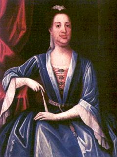 was appointed by Queen Anne of England, his cousin. He was described
during his governorship as being "a spendthrift, a
grafter, a bigoted oppressor and a drunken vain fool."35 He also
offended many colonists by his many appearances dressed in his wife's clothing, including
at her funeral. He even sat for a painting so dressed. He lived
1661-1723. Despite his troubled governorship, he was instrumental in
starting the construction of Fort Albany III which would eventually be called Fort Frederick.
was appointed by Queen Anne of England, his cousin. He was described
during his governorship as being "a spendthrift, a
grafter, a bigoted oppressor and a drunken vain fool."35 He also
offended many colonists by his many appearances dressed in his wife's clothing, including
at her funeral. He even sat for a painting so dressed. He lived
1661-1723. Despite his troubled governorship, he was instrumental in
starting the construction of Fort Albany III which would eventually be called Fort Frederick.
"While in Albany, Cornbury undertook to replace the stockaded fort with a new one of stone. Plans were set in motion to have the fort redesigned and relocated to higher ground in order to provide better defense at a lower cost. On August 15, 1702 the cornerstone of the new fort was completed, and he expected the walls to reach five feet in height before the first frost."
Lord Cornbury
The importance of that height was so that the soldiers could fire over the wall while standing behind the
wall for protection. Fort Frederick took over 30 years to build, it being completed long after Cornbury's death.
I don't believe that Fort Albany III was built uphill as Governor Cornbury had planned. I believe it was built in the same spot as the wooden fort. Roemer drew a plan of the two forts with the two of them overlapping. Since the stone fort was larger, the wooden fort could have fit entirely inside of it.
Fort Frederick (1738-1786c)
Fort Frederick Receives its Name
"It was finally reported to the Board of Trade on June 2, 1738 that the stone fort was completed at last and named "Fort Frederick" in honor of Frederick Louis, the eldest son of King George II of Great Britain. It was a 200-foot square structure with a bastion at each corner. Within the structure a single, long, brick two-story barracks existed along one curtain wall and an equally long two-story brick "Governor's House" along the opposite side. Each building had bedsteads for 40 men. A garrison of 300 could be maintained in the fort. The fort mounted eight or ten cannon, most of them 32-pounders."
http://www.dmna.state.ny.us/forts/fortsE_L/frederickFort.htm
So, the name Fort Frederick was not given to the fort until 1738. Before that year, it was apparently called Fort Albany.100 I have read a report that Governor Cornbury unoffially called it Fort Anne. However, at the same time in New York city where he spent much of his time, that fort had been renamed Fort Anne and/or Queen's Fort. I would need another source before accepting that Cornbury referred to both forts with the same or similar name.
Collections on the History of Albany, From Its Discovery To The Present Time... by Joel Munsell (1867), vol. 2
Diary of Rev. Samuel Chandler. 1755
374 [periods and commas inserted by me]
The city of Albany. Has 2 Chh., an English & a dutch. tis situated on the west side of Hudsons River abt 155 miles from New York. the Town or City is picadoed abt 2 miles round. on the west side on a High Eminence is a Fort or Citadell. Stone & Lime. 4 Bastions, acute Angles abt 45º to handsome buildings or Barracks. Brick fences, but stone on the back side. abt 14 Guns, 2 before the Gate. Garrisoned by an independent company of 100 men, Captain Rutherford. 15 men mounted upon guard the east side of the fort next the town. abt 24 loop holes upon the Parapets. the 2 chh are in Broad [State] street that goes from the Fort to the water, and a market between them. Some Stone Houses, many Brick & some of the streets paved though irregular and rough. Fort from the river abt half a mile. the chh are stone. the House Generally Ends to ye street & brick ends & stone & wood Back & gutters all along reaching far over the streets. Many rows of small Button trees along the streets, the Brick Houses many of them curiously floured with Black Bricks & dated with the same. the Governours house has 2 Hearts in Black brick. House chiefly but one story high & Brick ends notched Like steps. window shutters, & loop holes in sellars. On the Top of the Houses, for weather, cocks, Horses, Lions, Geese, Sloops, &c &c. Their Bells very often ringing, and not tool for a Funeral. The settees at their doors are kept scoured very neat.
~~~~~~~~~~~~~~~~~
Demolition of Fort Frederick
Sometime April to July 1785
"City authorities authorize the demolition of Fort Frederick at the head of State street, and using of the stone for public improvements, and the clergy of various churches to be allowed material of the walls with which to build their churches."
Albany Chronicles, pg 365
September 15, 1786
"City employs workmen to remove the embankments of earth that had been cast up about Fort Frederick, that Yonkers (State) street might be widened now that the fort was gone."
Albany Chronicles, pg 368
~~~~~~~~~~~~~~~~~~
Location of Fort Albany III / Fort Frederick
Where the downward slope of Jonkers St. (now State St.) met the flat land, the wooden Albany Reformed Dutch Church was constructed in 1656 in the intersection with Handlaars St. (later called Market St., now Broadway). It was not centered in the intersection, but rather was a little to the west (upslope) where it may have been just out of the reach of the river's floods. This location caused the intersection to be very large, and resulted in a great width to the two streets leading away from it.
In 1792, it was reported that the width of State St. at Lodge St. was 158 feet. To demonstrate that width, today's State St. has a center island, and in each direction from there are two driving lanes, one diagonal parking lane, and a very wide sidewalk.
Fort Frederick was built higher up the slope than any streets which joined State St. at that time. The next map, shown in two orientations, was made by Horace Andrews, Albany's city engineer, in 1899 over a century after Fort Frederick had been torn down. It is in the possession of St. Peter's Episcopal Church today. Its importance is that it shows an outline of the stone Fort Frederick overlapping part of the present location of the church at the northeast corner of State and Lodge Streets. It is the best piece of evidence I have found concerning the exact location of the stone Fort Frederick.
North (more readable view)
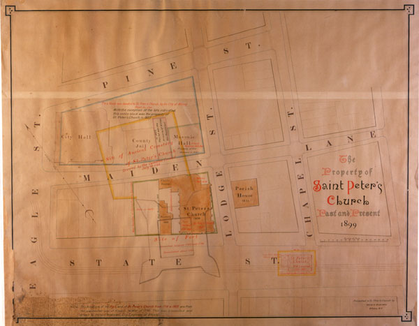
West at top (usual orientation of Albany maps)
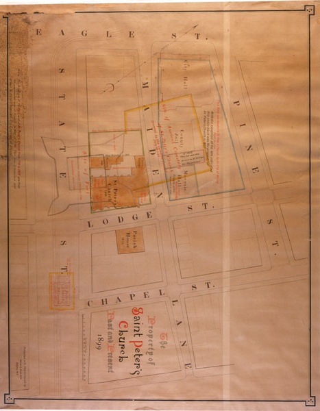 [2]
[2]
Eagle St. is the most westerly street shown on the map by Horace Andrews. Today, the slope of State St. extends upward beyond Eagle St. which is at the foot of the State Capitol. The Capitol was built where the slope is leveling off to join the flat land at the top of the slope.
When was Fort Albany II Torn Down? Where was it Located?
In 1715-1716, the first St. Peter's Episcopal Church was built of stone in the center of today's State St. It is shown on the Horace Andrews map. It was located downhill to the east of the fort by a block, at Barrack St. which later was called Chapel St. (see map above). It no longer reaches State St. The church was built very near the fort in order to serve the religious needs of its English occupants.

Here is a close-up of part of the Andrews map.
The land on which St. Peter's Church was built
was given to the church October 21, 1714.
East
"The Governor of the Province also assisted in the selection of a site for the building. In October 1714 the petition for a plot of ground in the center of Yonkers (now State) Street, at the foot of the eminence on which Fort Frederick reposed, was granted and a patent ordered to be issued. The little church under the shadow of the fort was the first house of worship of the Anglican Communion north of New York and west of the Hudson River."
http://www.stpeterschurchalbany.org/parish_history.htm
Problem: Like St. Peter's Church, the English palisaded fort was also downhill from the stone Fort Frederick. The stone fort was begun in 1702 and not completed until 1738. The only thing that makes sense to me is that the palisaded fort was in the middle of State St. (at Barrack/Chapel) from 1676 until the stone fort got sufficiently built to allow the earlier fort to be torn down (no later than 1714). With the wooden fort gone, I believe St. Peter's first church building was constructed on the same spot where the fort had been.
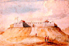
Was Fort Frederick built on a Prominent Hill?
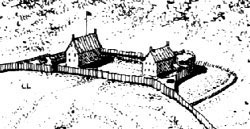
Although built on a hillside, paintings and drawings of Fort Frederick show the fort on top of a hill barely wider than the fort. It is shown that way in the drawing at the beginning of this webpage, and in one of the next two images. A more accurate depiction would show a continuation of the hillside behind, and above, the fort. However, a view from the bottom of State St. looking up at the fort might not show the land above the fort.
Because the palisade that connected to the fort are not shown in these images, I have thought that the hill was exaggerated. And, maybe it has been, but Paul R. Huey, archeologist, told me (pers. comm. 11-3-08) that some archeological work in that area found no evidence of the fort. All of the soil on which the fort had been built has apparently been removed, taking with it the artifacts. He said that the surface soil seen in other places had been removed right down to the clay.
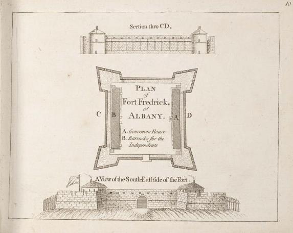
This section thru C-D shows the rear wall which is not part of the section.
"A View of the South-East side of the Fort" gives the direction accurately. For this webpage, however, directions work best if we call it the east side of the fort. It is the front of the fort. Notice the palisade wall of the city that joins the fort on two sides. Those logs are shown on several depictions of the fort.
Descriptions of the fort may have emphasized its prominence, which may have given rise to the depictions we see from later artists. All maps of the city of Albany show palisades surrounding the city and joining Fort Frederick on the north and south sides. Artists' conceptions of the fort on a prominent hill omit the palisade because of the difficulty of joining the palisade to the fort.
 [3]
[3]
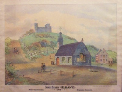
Print representing St. Peter's Church in 1715 with Fort Frederick in the background.
Photograph by Clifford Lamere, Oct 2008, at St. Peter's Church.
Today's St. Peter's Church would have been built where the rightmost bastion of the fort is pictured. I don't believe that the fort was on such a prominent hill. We know that it was on the side of a slope down to the river.
Collections on the History of Albany, From Its Discovery To The Present Time... by Joel Munsell (1867), vol. 2
pg 297
City Hall, Albany, 15th August, 1787
It being suggested to the Board that the Persons now employed in filling up their Lots with Sand, would instead thereof fill the same with Clay from the Fort, Provided they could with as much ease Load their Carts, and it being deemed necessary that the Road along the Fort should be widened; Therefore
Resolved that Mr. Recorder be empowered to employ two men, at the expence of this Board, for the purpose of Cutting and loosening the Ground and Clay along the South side of the Fort.
Quotes about Fort Frederick
"Other raids by French Indian allies took place throughout the frontier regions of New England in 1746, but had limited success. One of these raids penetrated as far as the New York colony. The attackers planned to attack Fort Frederick at Albany in 1745. Fort Frederick had been rebuilt early in the century in masonry, replacing the old wooden fort built after a Dutch defeat. The new fort was quite formidable with its four corner-bastions that mounted over twenty cannons. Not surprisingly, it held off the French assault." - Fortress America: : The Forts that Defended America, 1600 to the Present by J. E. Kaufmann & Tomasz Idzikowski (2004).
pg 61-62
Indians and Colonists at the Crossroads of Empire: The Albany Congress of 1754
Timothy J. Shannon, 2000
[pg 124]
"British Albany formed a defensive perimeter around Dutch Albany with palisades, blockhouses, and a fort. To a traveler arriving by way of the Hudson, this British presence became apparent only when moving away from the Dutch-defined riverside landings and markets. On a high, steep hill on the west end of the town stood Fort Frederick, a reminder of Albany's place in a larger empire. The fort impressed Hamilton, who noted its four bastions, each with "eight or ten great guns." Inside its walls were two brick buildings: the Governor's House, where New York's royal governor stayed when visiting Albany to treat with the Indians, and a barracks for British troops. About one hundred soldiers usually lived in the fort, rotating their duty with comrades farther west at Fort Hunter and Oswego. Kalm described the fort as the highest building in Albany, yet one poorly positioned to defend the city because higher ground commanded it beyond the palisades." [my emphasis]
Fort Frederick was about 3/4 of the way up the hillside, which was a military disadvantage.
"... the soldiers of Fort Frederick made up the bulk of the city's British population. Thomas Pownall described them as a desperate lot ... drunken and besotted with Rum and ... soon Invalids or worse. ... Some soldiers after retiring from the army settled in Albany as craftsmen or keepers of taverns and dramshops. They tended to settle in the city's southwestern corner, not far from the fort."
The Albany Congress of 1754, held at Fort Frederick
"For the Albany Congress [1754], a small village of about two hundred Indians suddenly appeared on the high ground beyond the city's fort. ...
Treaty conferences usually corresponded with the Indians' seasonal cycle of production. New York's governors preferred to convene them in the summer, when Indian males would be back from their hunting and fair weather allowed for holding public councils out-of-doors. Summer dipolomacy brought Indian men, women, and children to Albany during their regular trading season and stimulated the local economy."
Indians and Colonists at the Crossroads of Empire: The Albany Congress of 1754
Timothy J. Shannon, 2000
[pg 129]
www.nnp.org/nnp/publications/ABAFB/9.4.pdf
16.52-16.56 (Albany: University of
the State of New. York, 1920), 8; Paul R. Huey, “Archaeological
Excava- ...
. "Fort Frederick, 1676, Albany County, Albany. Originally a stockade of wood construction which replaced Fort Orange which was on the river. It was rebuilt as a masonry fort between 1702-35, on State Street hill (21 guns), originally with a stockade that enclosed the city. Torn down about 1789. Referred to in "Drums Along the Mohawk" as Fort Albany. A letter 2 April 1703 mentions a new fort is being built." [New York State Division of Military and Naval Affairs: Military History, Source]
http://www.nnp.org/nnp/publications/ABAFB/9.4.pdf
With the end of the "French and Indian Wars" [1754–1763] and the widthdrawal of the British troops, the Albany fort was without its intended occupants. In 1765, the abandoned fort, hospital, barracks, and other structures were purchased by the Albany corporation. No longer maintained by the provincial government, the fort fell into rapid disrepair.
http://www.nysm.nysed.gov/research_collections/research/history/albany/loc/fortalbany.html
pg 76
June 1676
"The newly constructed fortification at the head of Yonkers (State) street is named Fort Frederick, and Ensign Silvester Salisbury placed in command."
Cuyler Reynolds, pg 76
(defining the position of it so that standing in the center of State street, the northeast bastion was placed on the site of the tower of the future St. Peter's Church, at northwest corner of State and Lodge streets),
~~~~~~~~~~~~~~~~~
The Archeology of Fort Orange and Beverwijck, by Paul R. Huey, Bureau of Historic Sites, New York State Office of Parks, Recreation and Historic Preservation. Published in A Beautiful and Fruitful Place: Selected Rensselaerswijck Seminar Papers by The New Netherland Project (1991), pg 334.
http://www.nnp.org/nnp/publications/ABAFB/9.4.pdf
"Remains of wooden water pipes, consisting of slender logs cut flat on one side and grooved to form a channel which was covered with a plank nailed down, probably represent the water system which was installed in Albany in 1678."
~~~~~~~~~~~~~~~~
The watercolor by James Eights shown on the left represents his mid-nineteenth century visualization of the fort taken directly from a map made a hundred years earlier. The fort reached its high point of grandeur during the Seven Year's War when the British army was encamped in Albany and its environs. During that occupation, the British further fortified the Albany structure and added external barracks, magazines, storehouses, and a hospital.
With the end of the "French and Indian Wars" and the widthdrawl of the British troops, the Albany fort was without its intended occupants. In 1765, the abandoned fort, hospital, barracks, and other structures were purchased by the Albany corporation. No longer maintained by the provincial government, the fort fell into rapid disrepair. A map of Albany dated 1770 shows the fort in an outlined form that testifies to its dilapitated condition. During the 1760s, local people had salvaged stone, wood, and metal parts from the fort - despite the admonitions of the common council against such actions.
http://www.nysm.nysed.gov/albany/loc/fortalbany.html
~~~~~~~~~~~~~~~~~
In my last email, I started with the 1758 map which showed the fort as well as a hospital and barracks(?) both H-shaped. The location of the hospital seems to be known. It was apparently at Lodge and Pine. Here is what an historical marker says. http://www.nysm.nysed.gov/historicmarkers/hisall.cfm
COLONIAL HOSPITAL
NEAR THIS SITE STOOD THE
MILITARY HOSPITAL WHERE THE
WOUNDED FROM TICONDEROGA,
1758 AND SARATOGA, 1777
WERE ATTENDED.
Location: LODGE AND PINE STS.
If the right edge of the map is north, then the hospital is due north of the northeast bastion of the fort which is at current St. Peter's. If Horace Andrews saw this map and knew the hospital was on Lodge, it would then appear that the stone fort was at State and Lodge.
~~~~~~~~~~~~~~~~
Plan of Albany in 1695 - map by Rev. John Miller, British chaplain
South 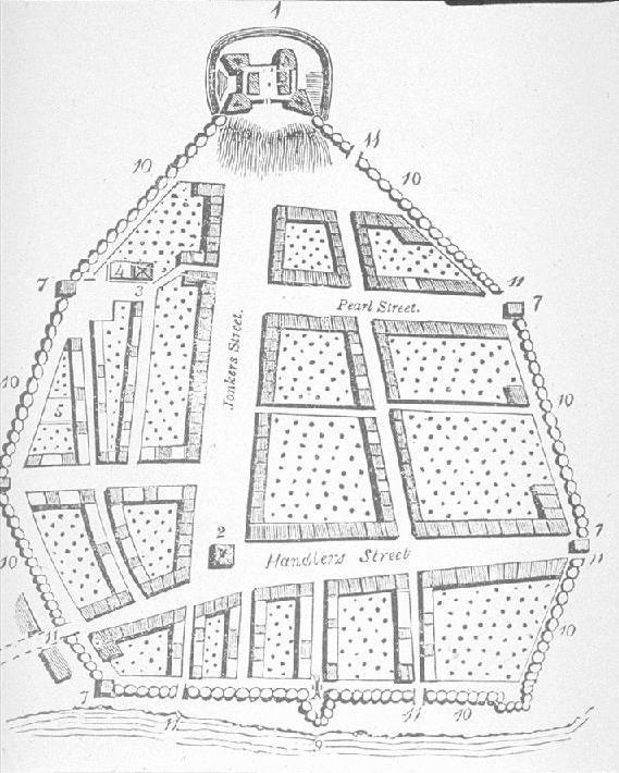 North
North
East
Legend: [from Random Recollections of Albany, from 1800 to 1808, (1866) by Gorham A. Worth, pg 22]
Surrounded by a wall of wooden posts ten feet high
1. The Fort 7. Blockhouses
2. Dutch Calvinistic Church 8. [unused number]
3. German Lutheran Church 9. A great gun to clear a gulley
4. Lutheran burial place 10. Stockades
5. Dutch Church burial place 11. City gates, six in number
6. Stadt House [City Hall]
[Stadt House was number 8, by mistake]
O'Callaghan. Documents Relative to the Colonial History of New York, vol 4, part 1 974.7 qD63
pg 790
"I have extended the Fort more Northwards By which means I shall entirely cover the West side of the Town which is that which lies exposed to danger..." September 24, 1702, from "Cornbury"
~~~~~~~~~~~~~~~~
http://www.nysm.nysed.gov/albany/art/kalm.html
"Peter Kalm's Travels in North America recounted his time in the colonies from 1748 to 1751. First published in 1770 and offered in many editions since, that massive work is one of the most often-utilized descriptive resources for early American history."
"There are two churches, one English and the other Dutch. The Dutch church stands a short distance from the river on the east side of the market. It is built of stone and in the middle it has a small steeple with a bell. It has but one minister who preaches twice every Sunday. The English church is situated on the hill at the west end of the market, directly under the fort. It is likewise built of stone but has no steeple. There is no service at the church at this time because they have no minister, but all the people understand Dutch, the garrison excepted. The minister of this church has a settled income of one hundred pounds sterling, which he gets from England...
"The fort lies higher than any other building on a high steep hill on the west side of the town. It is a great building of stone surrounded with high and thick walls. Its location is very bad, as it can serve only to keep off plundering parties without being able to sustain a siege. There are numerous high hills to the west of the fort, which command it, and from which one may see all that is done within it. There is commonly and [an] officer and a number of soldiers quartered in it. They way [say?] the fort contains a spring of water."
[ ] are mine. The "high steep hill" could be the eminence, or it could just mean the high steep hill that is there today. I believe one of the high hills to the west would be the section of land left between the ravines of the Rutten Kill and its tributary (the one you pointed out to me). There was also the high land near the Capitol that was moved.
Traces of wood-lined cellars were found... under State Street above North and South Pearl Streets. ...identity of two wooden cellars found in upper State Street above North and South Pearl Streets remains uncertain. Huey334 [Fort Albany II?]
The deep, rich deposits of debris and fill under State Street below North and South Pearl Streets were in complete contrast to the absence of such strata farther up the hill. The upper hill had been graded down, and this, combined with the filling at the foot of the hill, had resulted in a greatly decreased slope. This major change evidently occurred in the early 19th century. Before then, the State Street hill apparently rose steeply to the site of Fort Albany...
Huey 334
1710 Roemer - detailed map of Fort Albany. Extremely accurate according to Huey, pg 375 in Venema.
A history of Saint Peter's church in the city of Albany" Authors: Hooper, Joseph, 1851-1928; Battershall, Walton Wesley, 1840-1920
pg 63
Mr. Barclay had received a stipend of fifty pounds from the Propagation Society and an allowance as chaplain at Fort Albany.
pg 449
"Above the church, on an abrupt eminence which has since been levelled to the gradual ascent to the Capitol, stood Fort Frederick, which rep- resented the English sovereignty in the province, and whose northeast bastion extended over the site of the porch of the present St. Peter's."
A history of Saint Peter's church in the city of Albany" Authors: Hooper, Joseph, 1851-1928; Battershall, Walton Wesley, 1840-1920
Collections on the History of Albany, From Its Discovery To The Present Time... by Joel Munsell (1867), vol. 2
Journal of Jasper Dankers and Peter Sluyter -1680. [title on pg 358]
369-370. In the afternoon, we took a walk to an island upon the end of which there is a fort built, they say, by the Spaniards. That a fort has been there is evident enough from the earth thrown up, but it is not to be supposed that the Spaniards came so far inland to build forts... This spot is a short hour's distance below Albany, on the west side of the river...
370. We were invited to the fort by the Heer commandant... He... was... a Scotchman.
371. It [Albany]
was formery named the Fuyck, by the Hollanders... It is nearly
square, and lies against a hill, with several good streets, on which there may
be about eighty or ninety houses. Fort Orange, constructed by the Dutch,
lies below on the bank of the river, and is set off by palisades, filled in with
earth on the inside. It is now abandoned by the English, who have built a
similar one back of the town, high up on the declivity of the hill, from whence
it can command the place. From the other side of this fort the inhabitants
have brought a spring of water, under the fort, and underground into the town,
where they have in several places always fountains of clear, fresh, cool
water. ![]()
~~~~~~~~~~~~~~~~~~~~~~~